
[The following is derived from a talk I gave to the Washington Map Society in 2009. Given the recent media attention concerning the depletion of the world’s water resources this essay, perhaps, has more relevance than I thought when it was originally presented.]
Maps, Water Rights and Regulation: Thomas Jefferson, James Madison and the Battle over the Waters of the Potomac River
© Edward C. Papenfuse, Maryland State Archivist and Commissioner of Land Patents, emeritus
There is an ancient proverb made popular by Benjamin Franklin that runs:
For want of a nail the shoe was lost;
for want of the shoe the horse was lost;
and for want of a horse the rider was lost.
-- Thoughts by Benjamin Franklin from Poor Richard's Almanac, or from his letters, on life and prosperity.1
A title for this essay might more appropriately be “For want of a Map the Case was Lost.”
The U. S. Supreme Court case of Virginia vs. Maryland (Virginia v. Maryland, 540 U.S. 56 (2003) over what governmental entity has the right to regulate the consumption of water from the Potomac cannot be resolved as simply as finding an accurate, reliable map of jurisdictional boundaries. There are complex issues of 'riparian rights' and 'reasonable use,' not to mention efforts to apply an old principal of littoral rights, usually reserved for any body of water except a river, and the international law concept of Thalweg, which places nation state boundaries in the middle of shared rivers.2 Yet in writing about why Maryland lost the case in the Baltimore Daily Record, Andrew Baida, who argued the case for Maryland before the Supreme Court, contended that it was a single map that contributed mightily to his clients defeat.3
In attempting to deal with the questions of water rights and their regulation, the lawyer and the historian are faced with a many headed hydra of differing opinions, legal and otherwise. For the layperson the overview of the problems of water regulation provided by the online Water Encyclopedia is informative, if discouraging.4
Surface water and groundwater are transboundary resources that often cross political boundaries. Generally, under the United States' federal system of government, no single governmental level has absolute sovereign authority over water. Effective implementation of water policies requires coordination among all levels of government, various administrative commissions, and regional independent agencies.
A complex legal and administrative framework controls how federal, tribal, state, and local governments share legal authority over water quality and quantity, as well as over broader water development and management issues. This system is based on common law, constitutional and statutory law, local custom, judicial decisions, and international treaties. Accordingly, different governmental levels have primary authority over certain water issues. The federal government has undisputed sovereignty to develop and manage navigation on interstate or international bodies of water used for commerce. Conversely, primarily state or local governments govern intrastate water quantity and quality issues. Between these extremes, each level of government vigorously guards its authority as the balance of power fluctuates to meet changing water priorities.5
One of the best studies of the complexities of dealing with the Potomac River, one of three principal rivers on the Western Shore wholly within the 1632 Charter boundaries of Maryland, was published in 1976. It was entitled Legal Rights in Potomac Waters. Proceedings of a Conference at Harper's Ferry, West Virginia, sponsored by the Interstate Commission on the Potomac River Basin and the Maryland Department of Natural Resources, edited by Professor Garrett Power. In his foreword, Professor Power outlined the principal questions posed by the conference, questions that in large measure today remain largely unanswered:
Taken together, the papers pose the water supply issues facing the Potomac Basin, ranging from general to specific:
Is there a need for an agency with overall water resource planning and management powers in the Potomac Basin? If so,how should it be organized and financed? How should water be priced in the Washington metropolitan area? Is the area in fact "water short"? If so, is the problem one of base flow, peak demand, or both?
Should the dams and reservoirs proposed by the Army Corps of Engineers for Bloomington, Sixes Bridge and Verona be constructed? If so, when? Do the States of West Virginia and Pennsylvania have the power to divert Potomac waters into other basins? If so, are there any legal constraints on such authority and what are they?
Under present law, must Virginia and the Corps of Engineers obtain permission from the State of Maryland before appropriating Potomac waters? If so, can Maryland prerogatives be diminished without its consent?
Must specific statutes of the various states be changed in order to achieve an economically efficient allocation of water resources? If so, which laws need be modified? The papers which follow analyze these questions in some detail. A great deal more work may provide some answers. 6
In the intervening years insufficient resources have been allocated to water resource management generally, a matter addressed by the New York Times series on America's toxic waters, and Maryland has had great difficulty in asserting regulatory authority over the waters of the Potomac, which forms its southern boundary.7 In the era of the American Revolution, no one was more of an expert on the latter issue than Thomas Jefferson of Virginia who spent time in Annapolis researching Maryland's Charter and laws on the topic and instigated the discussions that led to the 1785 Mount Vernon conference on the regulation of the Potomac.8
One of the trick questions that is fun to ask visitors to Annapolis is "who was the first president to live in the White House?" If the visitor had watched the Adams Family chronicles on HBO, or visited the White House web site, the answer would be quick and decisive: John Adams. Not so. The first future president to live in a dwelling in Annapolis called the "White House" was Thomas Jefferson. He lived there while attending Congress as a delegate in the Winter and Spring of 1783-1784, before being sent to France as our representative at the Court of Louis the XVI.9
While at the White House in Annapolis, Jefferson put the finishing touches on his Notes on Virginia, in addition to his official duties which included authoring the two ordinances governing the settlement of the Ohio country, writing the protocol by which George Washington made his bow to civil authority by resigning his commission as commander in chief, and composing the text of the Congressional proclamation announcing the ratification of the Treaty of Paris ending the Revolution. Jefferson had the official first word, and the official last word in the war for independence with his Declaration of 1776 and the Proclamation of Peace, of 1784, but he could find no one in Annapolis willing to publish his Notes. As he wrote Madison, "I could not get my notes printed here, & therefore refer it till I shall cross the waters where I will have a few signed struck off & send you one." 10 That meant that he would attend to such details as a map to accompany the Notes when he got to Paris. The consequences for the debate over the ownership of the Potomac would be important. In citing Jefferson's Notes on the question, reference would be made by both Virginia and Maryland to the text of the European edition, and not those published on Jefferson's return to the States. All would ignore the maps which were drawn to accompany each edition. To be sure, the Virginia Counsel in the 2003 Supreme Court case, Stuart A. Raphael, was aware of the American editions of the map, and reminded me of their existence, but neither side brought them into the argument before the court, nor had they been examined by any of the several preceding efforts to resolve the conflict. All of us would have done well to have read Coolie Verner on the subject to familiarize ourselves with the importance Jefferson placed on the accuracy of his maps to accompany his Notes, and the choices made for the American editions that followed the adoption of the Compact of 1785.11
In the long struggle between Virginia and Maryland over the ownership and use of the Potomac, Jefferson did not have the first word, but perhaps he should have the last, despite a 2003 decision of the U. S. Supreme Court, as evidenced in the careful cartographic evidence he supplied as an integral part of the first American editions of his Notes on Virginia.
While in Annapolis, James Madison asked him on March 16, 1784, to look into the question of Maryland's ownership of the Potomac:
The Charter granted in 1732[1632] to Lord Baltimore makes, if I mistake not, the Southern Shore of the Potowmac, the boundary of Maryland on that side. The Constitution of Virginia cedes to that State "all the territories contained within its charter with all the rights of property, jurisdiction and Government and all other rights whatsoever, which might at any time have been claimed by Virginia, excepting only the free navigation and use of the Rivers Potowmac and Pokomoque etc." It is not to be apprehended that this language will be constructed into an entire relinquishment of the Jurisdiction of these rivers, and will not such a construction be fatal to our port regulations on that side and otherwise highly inconvenient? I was told on my journey along the Potowmac of several flagrant evasions which had been practiced with impunity and success, by foreign vessels which had loaded in Alexandria. The jurisdiction of half the rivers ought to have been expressly reserved. The terms of the surrender are the more extraordinary, as the patents of the N. Neck place the whole river potowmac within the Government of Virginia; so that we were armed with a title both of prior and posterior date, to that of Maryland. What will be the best course to repair the error? --to extend our laws upon the River, making Maryland the plaintiff if she chooses to contest their authority-- to state the case to her at once and propose a settlement by negociation-- or to propose a mutual appointment of commissioners for the general purpose of preserving a harmony and efficacy in the regulations on both sides. The last mode squares best with my present ideas. It can give no irritation to Maryld. It can weaken no plea of Virga. It will give Maryland an opportunity of stirring the question if she chooses, and will not be fruitless if Maryland should admit our jurisdiction. If I see the subject in its true light no time should be lost in fixing the interest of Virginia. The good humor into which the cession of the back lands must have put Maryland, forms an apt crisis for any negociation which may be necessary. You will be able probably to look into her charter and her laws, and to collect the leading sentiments relative to the matter . 12
On April 25, 1784, Jefferson replied, after discussing the matter with Thomas Stone, one of Maryland's signers of the Declaration of Independence, and the following year a negotiator on behalf of Maryland at the conference of the two states held at Mount Vernon that resulted in the Compact of 1785. He told Madison that he liked the method Madison proposed, and noted that “to introduce this the more easily I have conversed with Mr. Stone (one of their delegates) on the subject and finding him of the same opinion have told him I would by letters bring the subject forward on our part. They will consider it therefore as originated by this conversation.”13 In other words, the Marylanders who would engage in negotiating with Virginia over the regulation of the Potomac, saw Jefferson as a principal spokesperson for the Virginia point of view, not knowing that the ideas being promulgated by Jefferson were actually Madison's.
At the end of March, 1785, after cooling their heels in Alexandria waiting for the Virginia delegation to arrive, the Marylanders appointed to negotiate with Virginia over regulating the Potomac and the Chesapeake, were invited to Mount Vernon by George Washington, where finally both sides got to work. Over several days, George Mason and Alexander Henderson for Virginia, and Daniel of St. Thomas Jenifer, Thomas Stone, and Samuel Chase for Maryland toiled over the text of a proposed agreement, enjoying the ample hospitality of their host. The result was the Compact of 1785, the 7th article of which became the central point of controversy over which state should have the right to regulate the use of the waters of the Potomac above and below tidewater. That seventh article, the only article to survive the repeal of the compact in 1958, reads:
The Citizens of each State respectively shall have full property in the Shores of Potomack River adjoining their Lands with all Emoluments and advantages thereunto belonging and the privilege of making and carrying out Wharfs and other Improvements so as not to obstruct or injure the Navigation of the River; But the Rights of fishing the River shall be common to and equally enjoyed by the Citizens of both States, provided that such common Rights be not exercised by the Citizens of one State to the Hinderance or Disturbance of the Fisheries on the Shores of the other State, and that the Citizens of neither State shall have a Right to fish with Nets or Seines on the Shores of the other. 14
The meaning of this article is central to every arbitration and court case to the present time concerning regulatory jurisdiction over the Potomac River. What did it mean as to the use and ownership of the waters of the River? Does ''other Improvements'' extend to water consumption? Did the provision encompass the whole of the River or only the portion that was navigable in 1785? Could it have been, as Justice Kennedy asserts in his dissent, in essence “a predictable and intelligent hedging agreement (protecting both from the danger that at some later point the other’s claim to full and clear title would be confirmed by a competent legal authority)”? 15
Madison believed that the provisions of the Compact of 1785 only applied to the navigable portion of the River . In January of 1785 he wrote Jefferson that It now makes a part of the task alloted to the Commissrs. who are to settle with Maryd. the jurisdiction & navigation of Potowmac below tide water [emphasis added. 16
Shortly after the Commissioners had met, Madison would write Jefferson, on April 27, 1785 :
I understand that Chase and Jennifer on the part of Maryland, Mason and Henderson on the part of Virginia have had a meeting on the proposition of Virga. for settling the navigation and jurisdiction of Potowmac below the falls, and have agreed to report to the two assemblies, the establishment of a concurrent jurisdiction on that river and Chesapeak. The most amicable spirit is said to have governed the negociation. [emphasis added]17
Not only did Madison understand the intent and reach of the Compact of 1785, he was the floor manager who shepherded it through the approval process of the Virginia House of Delegates.
Perhaps the negotiations were somewhat too amicable on reflection, as far as the Virginia negotiators were concerned. George Mason particularly regretted the ambiguous language and apparent intent of the 7th article to limit the use of fishing nets and seines off an owner's property on either side of the river.
The Fisherys upon the Potomack River are becoming a very important Object; & therefore I cou'd wish the above Clause [7] in the Compact properly amended: if the Amendment goes no further than I have mentioned [adding the words of the citizens to clarify that land owners could fish with nets and seines off their own shores], it will occasion no Objection from Maryland; and I wish the Article to be no[t] otherwise altered; for this was the most difficult Business we had to settle with the Maryland Commissioners. The idea of the Right of fishing on both Shores of the Potomack River is one the Marylanders are not fond of parting with; and I trust it will be found we have obtained every thing for Virginia, with Respect to the Potomac River, which she can desire. ..." 18
In granting the right to 'full property in the Shores of Potomack River adjoining their Lands with all Emoluments and advantages thereunto belonging and the privilege of making and carrying out Wharfs and other Improvements so as not to obstruct or injure the Navigation of the River,' Maryland only gave up its right to regulate with regard to fishing off one's own land, and indeed retained the right to regulate (in existence since June 20, 1632) all other matters, including the licensing of the use of the river in every respect from fishing to slot machines on piers extending out from the Virginia side. . "Full Property in the shores adjoining their land" in particular means the full property and its regulation as determined by the sovereign authority and ultimate owner of the River. “Full Property in the shores adjoining their land” meant Maryland precedent and Maryland land granting procedures (including the right of the state to take land and water back for public purposes) over the whole of the Potomac, not Virginia law and precedent as none extended beyond the southern bank of the Potomac. George Mason knew that, and wanted to be certain that he would not be prohibited from using fishing nets and seines off his own land which bordered the Potomac on the South side. Mason did not get his wish. The language of the Compact of 1785 was not changed and despite the acknowledgment in the 7th article of 'full property' the controversy over the meaning of the words of the compact would rage for another two hundred and eighteen years, possibly even longer.
Unfortunately for Maryland, the Supreme Court of the United States chose to disagree with Jefferson, Madison, and Mason, with regard to their view of the facts regarding Maryland's “full property” and regulatory powers over the waters of the Potomac. Instead the court decided in 2003 that Fairfax Virginia could withdraw as much water as she cared to (as long as it did not impair navigation), without regulation from Maryland.19
At dispute was the desire of Fairfax County Virginia to take water from the Potomac out of the middle of the river at a place above Great Falls. For a long time the County had been taking water through an intake on the south bank of the Potomac near the Trump golf course and wanted to move to the center of the river where the water was less silty.
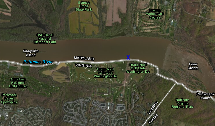
The blue ‘x’ marks the spot from which Fairfax sought to move its intake pipe to the center of the river without regulation by Maryland. Source: http://www.virginiaplaces.
The Supreme Court decision to permit Fairfax to go unregulated by Maryland was based upon the recommendations of a special master, Ralph I. Lancaster from Maine, who had considerable international law experience dealing with boundary disputes between the United States and its neighbor, Canada, particularly those stemming from inaccurate maps of what might be referred to as 'his neck of the woods'.20 With that background, it might be expected that he would pay particular attention to the cartographic evidence in the Virginia vs. Maryland case, but apparently he was so intent on proving that the 7th article of the Compact of 1785 applied to the whole of the Potomac River, which in turn meant that Fairfax Virginia could draw as much water as it cared to from the river near the Loudon County Virginia line, that he failed to do so. In fact, he accepted uncritically one map in particular as supporting the Virginia claim, making much of the importance of it as evidence against Maryland.
When it comes to using cartographic evidence in court cases, care needs to be taken as to reliability and accuracy. In the border dispute with Maryland, for example, there is a long history of maps that were inaccurate or misleading out of ignorance or intent. The first map to accurately depict Maryland's claim to the southern boundary of the Potomac River was published by Lord Baltimore in 1635, [illus], but when he republished it in 1670, he deliberately pushed the boundary to the northward two rows of trees (something an earlier Equity Master discovered in the course of settling the boundary disagreement with William Penn) [illus]. About that same year Augustine Herrman accurately depicted the boundary on the South Shore of the Potomac, but both his map, and the two Calvert maps had no factual basis for what they depicted as the location of the origin of the Potomac, the first font of the River. That would take several mapping expeditions and several competing cartographers in the mid 18th century, followed by a Supreme Court decision in the first decades of the 20th century, to resolve. The resulting maps drawn by William Mayo, John Warner, and others by 1747, as filed with the British Government, [illus] do not draw a distinct boundary line between Maryland and Virginia, but they led to the British decision in Lord Fairfax's favor that it is the northern branch of the Potomac not the southern, that forms the boundary with Maryland. In the 1790s, Maryland tried to assert it also owned the southern branch. At the time, Jefferson was shepherding the American editions of his Notes on Virginia through the press and found this expansion of the ownership argument intolerable, as he told Madison in a letter written in January, 1797:
I suppose you are informed of the proceedings commenced by the legislature of Maryland to claim the South branch of Patowmac as their boundary, and thus, of Albemarle now the central county of the state, to make a frontier. As it is impossible upon any consistent principles and after such a length of undisturbed possession that they can expect to establish their claim, it can be ascribed to no other than an intention to irritate and divide, and there can be no doubt from what bow the shaft is shot. However let us cultivate Pennsylvania and we need not fear the universe. The assembly have named me among those who are to manage this controversy. But I am so averse to motion and contest, and the other members are so fully equal to the business that I cannot undertake to act in it. I wish you were added to them....21
In the end, the Supreme Court in 1912 concurred with the decision of the British government in the 18th century that the north Branch of the Potomac was the boundary of what was, by then West Virginia, and ruled that the whole of the river was owned by Maryland to the low water mark (by all rights it should have been the high water mark). The river, according to the court, began at the Fairfax stone, so identified by a Maryland surveyor in 1787, Francis Deakins, when he laid out lots to be given to Revolutionary War veterans in compensation for their service.22
In his recommendation to the Supreme Court that Virginia had the right to withdraw water from the Potomac River without regulation from Maryland, Special Master Lancaster refused to acknowledge the fact that the Compact of 1785 was exclusively related to the navigable waters below Great Falls, and he accepted the boundary between the two states as found on Dennis Griffith's map of Maryland published in 1794, the same year that Jefferson published his second American edition of the Notes on Virginia.
Lancaster wrote:
A 1794 map of the State of Maryland, titled “Map of the State of Maryland Laid down from an actual Survey of all the principal Waters, public Roads, and Divisions of the Counties therein” and paid for in part by the Maryland
House of Delegates, shows the boundary between the two States as running down the middle of the Potomac.68 The delegates who reviewed the map while it was under development in 1792 found that it “appear[ed] to them to
be accurate” and would be “of great public utility.”69 In 1799, legislators “attentively examined” the map and
thought it “a work of great merit, ornament, and utility.”70 The map and the statements of Maryland legislators
constitute additional evidence to show that the negotiators of the 1785 Compact would not have understood that
Maryland had exclusive control of the Potomac and that Maryland would regulate Virginia’s exercise of rights
under it.23
Lancaster accepted this map as supplementary proof of his argument that Maryland acceded to and paid for the way Griffith depicted the boundary between the two states. In fact, Maryland did not endorse or accept the map as Griffith had hoped, possibly because of the deficiencies of the map, refusing to pay for it, casting poor Griffith into poverty and an early, now forgotten, grave. The details of Griffith's failed efforts to profit by making a large scale map of Maryland is detailed in a work available to both sides in the case, but went unnoticed by all, including the Special Master.24 While there is no record of an explicit complaint about how Griffith depicted the boundary between Maryland and Virginia, the map contains at least one other blatant error probably attributable to the ill-informed Philadelphia engraver, who also may have been responsible for depicting the boundary as shown. The map is dedicated to the Maryland House of Representatives instead of the Maryland House of Delegates, a fact that in no small measure may have contributed to Griffith's later difficulty in recouping his investment. As boundary evidence it is at least suspect and needs to be balanced with other more reliable examples such as the beautiful atlas plate by Mathew Carey published in 1814, and several other maps available for easy web review on David Ramsey's web site.25
Use of the general atlas maps as evidence, however, cuts both ways. Fielding Lucas, of Baltimore, who published several lovely maps of Maryland in the first decade of the 19th century follows Griffith and places the boundary squarely in the middle of the river to its source. Except for his Chesapeake Bay chart which he may have commissioned, Lucas 'borrowed” all of his maps from other map makers with little regard to their authorship or accuracy.
Instead it is important to seek out a map maker who is accurately informed by reliable authority on where state boundaries lie, being willing of course, to place the map maker and his sources into historical context. In the text of all the editions of the Notes on Virginia, which he first completed in Annapolis in the Spring of 1784, and edited in Paris for publication in London in 1787, Thomas Jefferson makes the same reference to the Potomac boundary.
From the text it is clear that Jefferson knew that the boundary of Maryland followed the south or Virginia side of the river by the manner in which he crossed the Bay from Watkins Point to Cinquac, “near the mouth of the Patowmac, thence by the Patowmac,, which is common to Virginia and Maryland, to the first fountain of its northern branch...” [emphasis added]26 But while the text is subject to interpretation, his maps accompanying his text are not.
What changed over the editions of the Notes was the map that Jefferson went to great trouble to have accompany the volume. With the first edition he was demonstrably unhappy with the map and chose to disclaim authorship of its contents. In 1786 he wrote the British spy Edward Bancroft that “I do not propose that my name shall appear on the map, because it will belong to its original authors, and because I do not wish to place myself at the bar of the public.”27
By the time he returned to America and had some time to prepare an American edition, he had changed his mind and did place his conclusions with regard to the boundaries of Virginia before the 'bar of the public.” Through his publisher, Mathew Carey of Philadelphia, he secured the services of a surveyor and map maker, Samuel Lewis, who had trained under George Washington.28 As Coolie Verner points out “this map, drawn by Samuel Lewis in 1794, is of particular interest as the first map of Virginia to be made, engraved, and printed in America. It appeared in many of Carey's atlases and similar publications as well as in other editions of the Notes by other publishers.”29 This is the map to which the Special Master and the Supreme Court should have paid particular attention as an effective counterweight to Dennis Griffith's map of Maryland.
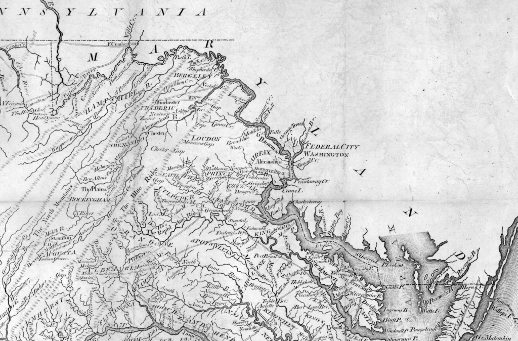
details from Samuel Lewis, The State of Virginia from the Best Authorities, 1794, author’s image collection

note how the boundary deliberately crosses to the south bank of the Potomac at just above Great Falls
The Lewis map accompanying Jefferson's first American editions of his Notes on Virginia establishes beyond doubt that by 1794, Samuel Lewis, a Virginia trained surveyor, working under contract with a distinguished Philadelphia map publisher and the direction of an indisputable authority on Virginia constitutional law, deliberately depicted for his client the administrative boundary of Maryland above Great Falls on the Potomac as exclusively Maryland, and the boundary below Great Falls as a cooperative responsibility of the two States as defined by the compact of 1785.30
In recent years (since 1978) the states with their local water authorities that consume water from the Potomac, and the District of Columbia, have worked together to share and monitor the water flow of the Potomac. They even signed an agreement in 1978 that tacitly acknowledged Maryland's right to issue permits with regard to who could withdraw Potomac water, and to what degree, especially in times of water scarcity.31 This was an agreement signed and ratified by Maryland, Virginia, the District of Columbia, and Congress, which apparently was not addressed by the Special Master in the 2003 Va. v. Maryland case.
But the answer to the future of the Potomac does not lie in water management agreements, formal or informal that have no firm base in constitutional law. It lies in water allocation and water quality regulation rooted in constitutional amendments defining the sovereign authority established to make such regulations. The need for Fairfax to extend its pipe into the middle of the Potomac in the fresh waters above tidewater was governed by the sediment that was accumulating at its then location because of runoff and over development. While the amount of water Fairfax could withdraw was in principle still governed by the 1978 and subsequent water allocation agreements, in fact it would be the number of new consumers in communities withdrawing water up stream and elsewhere along the Potomac that would constitute the continuing threat to the future water supply from the river.
In looking to the future of water resources and the right to administer them, what does this map of Jefferson's and a closer reading of the historical evidence not available in 1877 or 1910 really address? Should a recent decision of the Supreme Court based upon a poor understanding of the historical context and the historical evidence be reversed? It is not very likely any time soon that that might happen, and in the end it probably would be a wasted, expensive effort, even if successful. The Court is weary of the dispute between the two states, even though I believe a fair evaluation of all the evidence supports the dissents of Justices Kennedy and Stevens. In my opinion, our time and resources could be better spent. If we are to have clean water to drink and a Potomac that remains a vital waterway for the Nation, there needs to be another Mt. Vernon conference sanctioned by all parties in which constitutional amendments are produced that alter the way we regulate suburban sprawl and water consumption throughout the Chesapeake Bay watershed. In my opinion, we need to be addressing population growth and expansion with a watershed focus. [illus of Chesapeake Bay Watershed] Decisions as to growth and water regulation must be made in the context of the 64,000 or so square miles of the Chesapeake Bay watershed, not the provincial and expansionist views of individual states in the watershed, no matter what their current constitutional rights may be. To obtain that goal requires further constitutional changes at the Federal and State level, beyond the relatively powerless and advisory role of the Interstate Commission the Potomac River Basin (ICPRB).32 We get there by putting teeth into regional compacts in which local sovereign powers are surrendered by constitutional amendment to regional authorities that cross state boundaries. That is what the process of writing constitutions is all about. Perhaps it is time to revisit Jefferson on this issue as well. In a letter to Madison written in 1789, Jefferson mused that Constitutions need to be re-visited every 19 years. Maryland has such a provision in its State Constitution.33 Perhaps it is time to return to the negotiating table, if not to the Supreme Court, for a reversal of Virginia vs. Maryland through constitutional amendment and not litigation, that simply limits the use of our most precious resource?34
1See editions of Poor Richard's Almanac on google for the text. According to one source: For Want of a Nail: Changing Conceptions of Agency. The year 1640 marks the first appearance in print (in any language) of a well-known proverb: For want of a naile the shoe is lost for want of a shoe the horse is lost for want of a horse the rider is lost.1 The saying first surfaced in George Herberts Outlandish Proverbs published ten years after the authors death in 1630. A well-known poet Herbert may have authored the maxim. [sources:] Post August 17 1931 8 (Available from ProQuest: "Display Ad 8"). Moon Paul. "Blending Popular Culture and Religious Instruction: Herbert's Outlandish Proverbs." Early Modern Literary Studies 2 no. 1 (1996): 1-6. Saunders Allen. "Mary Worth's Family." Los Angeles Times March 19 1944 D11 (Available from ProQuest: "Comic 11"). Stich Herman J. "Two Minutes of Optimism: Little Things and Big Effects." Los Angeles Times August 11 1922 4 (Available from ProQuest). Tomes Nancy. The Gospel of Germs : Men Women
2Review of this essay by Profesor Garrett Power, retired professor of Law, University of Maryland School of Law, to the author. Professor Power agrees with the Court and discounts the importance of the cartographic evidence presented here. In part he writes “According to the English common law a private owner of land abutting a public waterway had riparian (AKA littoral) rights to make to make reasonable use of the waters. The VA/ Md dispute is distinctive in that it is the sovereign state of VA claiming a riparian right to consume Potomac waters (rather than the private owner of waterfront property). What constitutes “reasonable” use has been decided on a case by case basis in thousands of decisions in over hundreds of years. There are no reliable “bright line” rules. In Va. v. Md (2003) the U.S Supreme Court is in essence deciding that the sovereign state of VA is reasonable exercising its riparian rights to Potomac waters when it withdraws freshwater for public water supply purposes. The adoption of this pragmatic “rule of reason” is not inconsistent with the history or maps from the region.” For riparian rights, littoral rights, and the Thalweg doctrine see helpful articles in Wikipedia: http://en.wikipedia.org/wiki/
3Baida, Andrew H. "The Art of Appellate Advocacy: Virginia v. Maryland: The real reason why Virginia won." The Daily Record, 8 October 2004.
4http://www.waterencyclopedia.
5ibid.
6See: http://msa.maryland.gov/
7http://projects.nytimes.com/
8As George Mason, one of the negotiators at Mount Vernon for Virginia pointed out, the Virginia delegation's instructions, which they received only after they had concluded their deliberations, limited them to negotiating about the Potomac River only. When the broader agreement reached Richmond, James Madison,the floor leader, ignored the instructions and shepherded the agreement through passage unchanged by the Virginia legislature. See Robert A. Rutland, The Papers of George Mason, 1725-1792, Vol. II, 1779-1786, Chapel Hill: University of North Carolina Press, 1970, pp. 812-838. The historical evidence, apart from maps is expertly reviewed by Ron Hoffman in 2001 in his affidavit filed on behalf of Maryland in the Virginia v. Maryland case. See:http://msa.maryland.gov/
9The Annapolis 'White House” was on the site of the current annex to the Anne Arundel Court House and was owned by Daniel Dulany, Sr., a prominent Annapolis lawyer who did not support the Revolution, but remained in Maryland as a non-juror, protected by his many friends. The details of Jefferson's rental and use of the house while in Annapolis are documented in a forthcoming essay by the author.
10Thomas Jefferson to James Madison, May 25, 1784, http://memory.loc.gov/ammem/
11Coolie Verner, The Maps and Plates Appearing with the Several Editions of Mr. Jefferson's “Notes on the State of Virginia” in the Virginia Magazine of History and Biography, vol. 59, no. 1, January 1951, pp. 21-33.
12Smith, Republic of Letters, I:302-303
13 Smith, Republic of Letters, I:310
14Rutland, The Papers of George Mason, vol II, p. 818.
15http://www.law.cornell.edu/
16Madison took a keen interest in the work of the Commissioners, and if a clerk had not failed to deliver his appointment in a timely fashion, probably would have attended the negotiations. On July 3, 1784, Madison wrote Jefferson that Col. Mason, the Attorney, Mr. Henderson and myself are to negociate with Maryland if she will appoint Commissioners to establish regulations for the Potowmac. Smith, The Republic of Letters, I:323. As Robert Rutland points out in his edition of George Mason's papers, even Mason did not get official word of his appointment and the meeting. He and Henderson joined the deliberations because the Maryland delegation told him they were on their way. So ineptly did the Richmond government handle the appointments that Mason and Henderson negotiated in the dark without instructions, only to find that they had gone far beyond what the Virginia General Assembly instructed them to do. Rutland, The Papers of George Mason, vol. II, pp. 812-814.
17Jefferson Papers, VIII:113
18George Mason to James Madison, December 7, 1785. (Mason Papers, vol. II, pp.837-838.
19http://www.law.cornell.edu/
20http://www.pierceatwood.com/
21Smith, Republic of Letters, I:960-61; http://memory.loc.gov/cgi-bin/
22This is a complex case which deserved greater critical attention than it received from the Special Master. All of the relevant documents in the two related decisions of the Supreme Court (1910 and 1912) are to be found at: Maryland State Archives, 1891/10, U. S. Supreme Court, Original No. 1: State of Maryland vs State of West Virginia. Bill of Complaint and Answer (Old Accession No.: 18,011-1) MSA S 58-15 For multilayer tif images of MSA S 58-15 for whole document printing, click here. These tend to be very large images and will take some time to load
23 Special Master's report and appendix
24Edward C. Papenfuse and Joseph M. Coale III, The Hammond Harwood House Atlas of Historical Maps of Maryland, 1608-1908, Baltimore: The Johns Hopkins University Press, 1982, pp. 48-53, and notes 9-15, p. 125. A revised edition in 2002 takes the Special Master to task for ignoring the cartographic evidence of Virginia's acceding to Maryland's regulation of slots and fishing on piers off the Virginia shores below tidewater.
25See: http://www.davidrumsey.com/
26http://books.google.com/
27As quoted in Verner, Maps and Plates, p. 27
28See P. Lee Phillips, “Some Early Maps of Virginia and the Makers, Including Plates Relating to the First Settlement of Jamestown”, in the Virginia Magazine of History and Biography, vol 15, pt. 1, 1907, pp. 71 ff. ... Washington, for example, was a surveyor and maker of maps, although none of his work is in printed form. The Library of Congress has several manuscript plans of his dating from 1750 to 1775. The most interesting is the large map (79 by 24 inches) made by him in '775. showing lands on the Great Kanawha river, in West Virginia, granted by the British Government in 1763 for his services in the Braddock Exposition. As stated on the map, it is "A copy of a survey made by Mr. Samuel Lewis, 1774, for G. Washington, for 2950 acres." That the question of the disposal of this land was receiving deep thought and consideration from Washington is shown in his correspondence of that time. The copy, entirely in Washington's handwriting, contains detailed notes, tables and explanatory plats, as would Ire expected from one so painstaking in all his affairs.
29Verner, Maps and Plates, p. 28.
30While all his later maps of Virginia and their derivatives adhere to the depiction of the boundary as he presented it for Jefferson's Notes, there are later editions of his atlas maps of Maryland that do not carry the boundary of the state on the south bank as far as great falls (see his 1795 map of Maryland) and later maps that follow Lewis do not show an administrative boundary at all. Why Lewis failed to extend his boundary line on the south bank as far a Great Falls on his 1795 map of Maryland is a mystery, but it does not affect the argument that what he did for Jefferson accurately reflects Jefferson's perception of the administrative boundary between the two States. As with all evidence, the historical context of creation is key to evaluating importance and relevance. A good place to view Lewis's maps on line is David Rumsey's map collection, http://www.davidrumsey.com/, although Rumsey does not have a copy of the map on line that Lewis drew for Jefferson and was included in the 1794 edition of Jefferson's Notes.
31See Stuart S. Schwartz, “Multiobjective Management of Potomac River Consumptive Use”, Journal of water Resource Planning and Management, September/October 2000, pp. 277-287.”
32For the interstate/DC agreements on the Potomac River Basin see: http://www.virginiaplaces.org/
33SEC. 2. It shall be the duty of the General Assembly to provide by Law for taking, at the general election to be held in the year nineteen hundred and seventy, and every twenty years thereafter, the sense of the People in regard to calling a Convention for altering this Constitution; and if a majority of voters at such election or elections shall vote for a Convention, the General Assembly, at its next session, shall provide by Law for the assembling of such convention, and for the election of Delegates thereto. Each County, and Legislative District of the City of Baltimore, shall have in such Convention a number of Delegates equal to its representation in both Houses at the time at which the Convention is called. But any Constitution, or change, or amendment of the existing Constitution, which may be adopted by such Convention, shall be submitted to the voters of this State, and shall have no effect unless the same shall have been adopted by a majority of the voters voting thereon (amended by Chapter 99, Acts of 1956, ratified Nov. 6, 1956). http://www.msa.md.gov/msa/
34“No society can make a perpetual constitution, or even a perpetual law. The earth belongs always to the living generation…Every constitution, then, and every law, naturally expires at the end of 19 years. If it be enforced longer, it is an act of force and not of right.” —Thomas Jefferson (in a letter to James Madison from Paris, September 6, 1789). http://hdl.loc.gov/loc.mss/
No comments:
Post a Comment