
A Birthday Present for Maryland: A New Book about Augustine Herrman’s Map of Virginia and Maryland, 1673
In October of 1659, Augustine Herrman, an expatriate Bohemian tobacco merchant born near Prague, but now living and working out of New Amsterdam, reported on a diplomatic mission to Maryland. Merchants in New Amsterdam had close ties to the Chesapeake where they carried on a vigorous trade in imported goods (including yellow bricks from Holland) and tobacco. Herrmann reported back to his superiors that there was definitely a need for a good map of the area. He wrote that
First of all, the South River [meaning the southern part of Chesapeake Bay] and the Virginias, with the lands and Kills between both, ought to be laid down on an exact scale as to longitude and latitude in a perfect map, that the extent fo country on both sides may be correctly seen, and the work afterwards proceeded with, for some maps which the English here are utterly imperfect and prejudicial to us. The sooner this is done, the better.[1]
The Dutch in New Amsterdam were noticeably parsimonious in their dealings with Herrman, but Lord Baltimore, who claimed all of two degrees of latitude of land and water north of Watkins Point opposite the mouth of the Potomac River, was not. Baltimore promised a large grant of land the perquisites of a manor lord to Herrman if he would come to Maryland and prepare his map. Herrman readily agreed and, early in 1661, at the age of thirty-eight, he came to stay. By the time of his death in 1686, at sixty-three, Lord Baltimore had rewarded his efforts, with some 25,000 acres on the Elk River in Cecil County, Maryland which herrman named Bohemia Manor after the land of his birth. The first draft of his map was completed as early as January 1661, when Herrman was made a “denizen,” a privileged permanent resident, of Maryland by proclamation. That he may not have gotten to enjoy his landed wealth as much as he had hoped may have been due to a disastrous second marriage, at least according to some Dutch missionaries to whom he offered to sell his manor in December 1679, six years after his map was published in London:
Augustine Hermans … was sick when we arrived at his house. ... We delivered to Augustine a letter from his son Ephraim, and related to him how we had travelled with him from the Manathans, and how he was, which rejoiced him. Becoming thus acquainted he showed us every kindness he could in his condition, as he was very miserable, both in soul and body. His plantation was going much into decay, as well as bis body, for want of attention. There was not a Christian man. as they term it, to serve him; nobody but negroes. All this was increased by a miserable, doubly miserable wife; but so miserable that I will not relate it here. All his children have been compelled on her account, to leave their father's house. He spoke to us of his land, and said he would never sell or hire it to Englishmen, but would sell it to us cheap, if we were inclined to buy.[2]
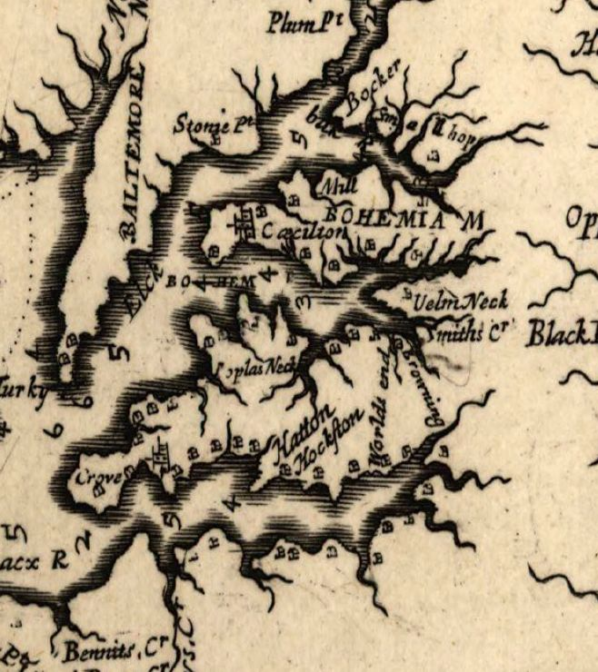
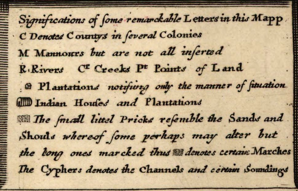
Detail from Herrman’s map showing his Bohemia manor and how he placed the locations of plantations and county seats, along with soundings on his map. The key to the symbols that Faithorne provided in the printed map is only partial:
Christian J. Koot, in A biography of a Map in Motion, Augustine Herrman’s Chesapeake (2017) has produced a thorough study of the political history of the map and the personal history of its creator after 1659. Professor Koot’s objective is to place the map into the context of Empire and the desire of the British and Lord Baltimore to know in geographical detail the extent of their domain. It is no accident that one of the surviving copies of Herrman’s map is to be found among the Blathwayt collection at Brown University. It is Blathwayt’s Atlas that was used by colonial administrators in the era of Charles II (1660-1685) and the maps that depict the Chesapeake Bay are in large measure based upon Herrman’s map.[3]
What is new and intriguing about Professor Koot’s book is the journey he takes the reader on from the inception of the map to the death of its creator. For the first time, based on Professor Koot’s informed speculation, we can understand the process by which Hermann, a merchant who spent considerable time (as did his contemporary, Jacob Leisler) in navigating the creeks and rivers of the Chesapeake. Professor Koot might have stressed more the role of the treasured and secretly held rutters (from the French meaning route) used by the captains employed by Hermann and Leisler, or possibly followed by Hermann himself (it is not known if Hermann captained his own merchant vessels). The rutters would have supplied rich detail of shoals, soundings, and sailing directions. Closely guarded and kept secret from competing merchants, few have survived, but a hint of the richness of detail they contained is to be found in Matthew Boyd Goldie’s An Early English Rutter: The Sea and Spatial Hermeneutics in the Fourteenth and Fifteenth Centuries.[4] The Dutch rutters were supposedly among the best and most detailed..
In four well-crafted chapters, Professor Koot introduces the merchant, the mapmaker, the planter, the patron and the engraver, and the consumers of the map, particularly the subsequent map makers and the English captains of Empire who aggressively pushed the bounds of their domains including the capture of New Amsterdam and transformed it into New York in 1664. Augustine Hermann left just in time for the life of a Lord of Manor on the banks of the upper Chesapeake.
It is there, as Professor Koot points out, he establishes his own mini empire, pushing his connections in trade northward towards the Delaware Bay, creating a well-traveled road for the illegal exporting of tobacco, eluding Lord Baltimore’s tax collector, and perhaps providing a path that in time would become an escape route for runaway slaves moving northward from Maryland’s Eastern Shore.
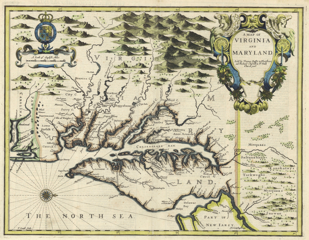
Francis Lamb, Virginia & Maryland, 1676 from Edward C. Papenfuse & Joseph M. Coale, and Edward C. Papenfuse. 2003. The Maryland State Archives atlas of historical maps of Maryland, 1608-1908.
While Professor Koot speculates that because so few copies of Herrman’s map were distributed (he could only find five extant copies), it did not become part of the cartographic canon of North America in the 19th and 20th centuries, it certainly had a direct influence on the more widely known printed maps of the late 17th and 18th centuries, with wholesale copying by such popular maps as Francis Lamb’s Virginia and Maryland, 1676, and Christopher Browne’s, A New Map of Virginia, Maryland …, 1685.
As to how many copies of the Herrman Map there remain, is still somewhat of a mystery. Professor Koot discovered one unknown copy among the papers of Samuel Pepys in immaculate condition and he opens his book with being enthralled by its pristine state as he was permitted to open it at the Pepys Library, Magdalen College, Cambridge. In all he counts five extant copies There indeed may be at least six. In 1935, J. Louis Kuethe, who painstakingly copied all the place names on Herman’s map and linked them to modern locations, indicated that there were two originals in the British Museum (now library), and one at the John Carter Brown library.[5] I found two at the Bibliotheque Nationale in France, one of which Arthur Houghton apparently pried away in exchange for a Gutenberg Bible, and gave to the Library of Congress. With the Pepys copy that makes six. Whether or not there were five or six, what is important is where they were found. All were in collections of individuals who were concerned with the extent of the British Empire, whether it be colonial officials or worried kings (such as the King of France whose stamp is marked in red on the copy given to the Library of Congress).
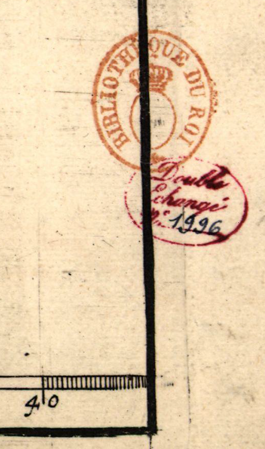
Original library stamp on the Library of Congress’s copy of Herrman’s map
While Professor Koot’s book provides a most readable, well illustrated, and informative journey from the inception of Herrman’s map through the details of its composition and the process of its printing, there remain a few minor unsolved mysteries that perhaps are of interest only to antiquarians and specialists in cartographic details.
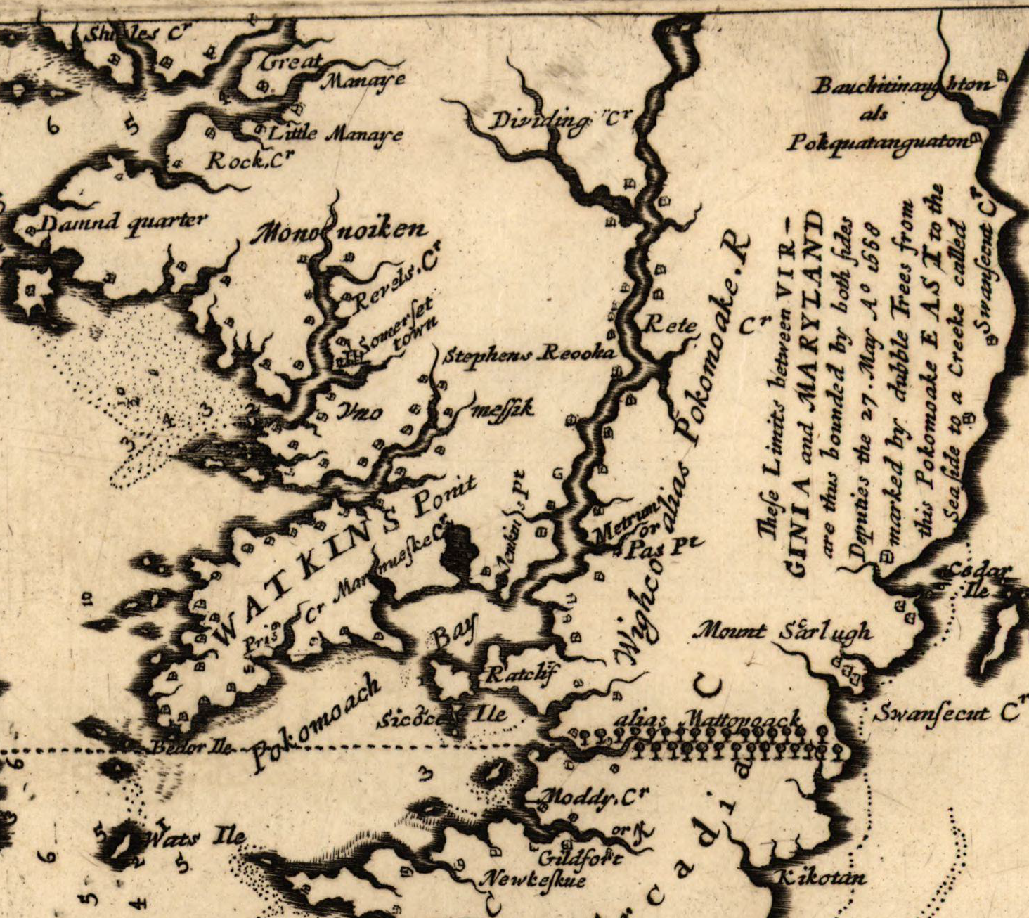
The most prominent local feature on Herrman’s map is the boldly labeled “Watkins Point” which was noted as the southern boundary point in Lord Baltimore’s charter (1632). Yet there was no such point and should have been shown on the map at best as a low marshy area that John Smith mistook as a point.[6]
Who was Thomas Withinbrook to whom Herrman assigned the copyright to his map? Was he a London apothecary who speculated in what he hoped would be the proceeds of the sale of Herrman’s map in England? Who is the Captain Tuly, Admiral of Maryland, whose ship is so prominent at the mouth of the Potomac guarding the St. George’s, now St. Mary’s river where Maryland’s capital town was located?

Why, of all the counties noted on the map, was Somerset left off, while counties appear that had yet to be officially designated (Cecil for example, which was not created until 1674). I suspect the answer to the last is relatively simple. The engraver, William Faithorne, probably simply missed it unintentionally. Herrman, according to one authority, “claimed that the engraving did not do justice to his original drawing. He said his map “was slobbered over by the engraver Faithorne defiling the prints by many errors.” [7] Somerset County should have been noted on the last, fourth plate (lower right quadrant) to have been engraved, and perhaps Faithorne had grown careless by then. Professor Koop’s chapter on the etching of the copper plates and the tedious process involved makes it clear that mistakes could have been made easily no matter how careful Faithorne was in the production of the plates.
In all, A Biography of a Map in Motion, is a welcome addition to the history of cartography and belongs in any library devoted to that history. Perhaps it is fitting to allow Professor Koop the last word about his book which places Augustine Herrman in a context that all previous studies of him and his map have missed, the lord of a manor for whom nationalist labels of “Bohemian” or “True American” would have little meaning.“ Just as Virginia and Maryland was wrapped in an imperial narrative that erased its local origins and its intercolonial perspective, the ways Americans memorialized Herrman obscured his understanding of the flexibility and permeability of empire.” While officially a citizen of Maryland, Herrman “found his greatest success moving between empires,” even when it was officially illegal to move the products of his manor along a road he built to evade the Proprietary taxes on tobacco.[8] His map and the subsequent derivatives did the same for others, just as it also helped define the geographical world of Maryland, the Chesapeake Bay and its tributaries.
Edward C. Papenfuse
Maryland State Archivist, retired
[1] See Papenfuse, Edward C., and Joseph M. Coale. 1982. The Hammond-Harwood House atlas of historical maps of Maryland, 1608-1908. Baltimore, Md: John Hopkins Univ. Press, p, 11 amd notes 20-21, p. 124. Hermann was born into a Protestant Bohemian family who fled to Holland in search of religious freedom. For details regarding origins of Augustine Herrman, see: Capek, Thomas, 1861-1950. Augustine Herrman of Bohemia Manor, monograph. Praha: [State printing office in Praha] 1930. George Peabody Library,
Non-Circ 920 H459C c. 1
[2] Danckaerts, Jasper, Bartlett Burleigh James, and John Franklin Jameson. 1913. Journal of Jasper Danckaerts, 1679-1680. Edited by Bartlett Burleigh James, ... and J. Franklin Jameson. New York: C. Scribner's Sons, p. 115.
[3] The Blathwayt Atlas: Maps Used by British Colonial Administrators in the Time of Charles II, Jeannette Black
Imago Mundi, Vol. 22 (1968), pp. 20-29. Julie King, et. al., in “Lord Baltimore and the Politics of Landscape” in Seventeenth-Century Maryland, The Occasional Papers of The Center for the Study of Democracy Volume 5, Number 1, Fall 2016, note the politics of Herrman’s map: The significance Cecil Calvert attached to inscribing his authority on the landscape is apparent on Augustine Herrman’s 1673 map, Virginia and Maryland as it is Planted and Inhabited. The map signified proprietary possession and authority through the marking and naming of places where the colony’s leaders met, including St. Mary’s City, Mattapany, and Notley Hall among others. The map showed the counties, all but one (St. Mary’s) named after Calvert family members, and the towns (or would-be towns) the Calverts had designated in a 1668 proclamation. Charles Calvert assured his father that “the names of all yor Lordshipps Mannors [are] Inserted [in Herrman’s map] as you direct me.” Missing from the map were the names of Calvert’s enemies, including Thomas Gerard and Josias Fendall. That the Herrman map constructed a colony as Baltimore wished it to be was not lost on Marylanders, including those antagonistic to the proprietor. In 1676 the author of an anti-Baltimore screed sent to royal authorities complained that, through the placement of the family’s seal on the map,Baltimore “puts himself in equall computation with . . . the Kings Majesty in the great map of Virginia and Maryland, prikkinge himself distinctly in, and the Kings Majesty out[,] of Maryland.”
[4] Speculum, vol. 90, no. 3, July 2015. Matthew Boyd Goldie is Professor of English at Rider University, Lawrenceville, New Jersey (e-mail: mgoldie@rider.edu).
[5] J. Louis Kuethe, A Gazetteer of maryland, A. D. 1673, Maryland Historical Magazine, December, 1935, vol. 30, no. 4, pp. 310-335.
[6] See: http://msa.maryland.gov/
[7] Heck, Earl L. W. 2007. Augustine Herrman: beginner of the Virginia tobacco trade, merchant of New Amsterdam and first lord of Bohemia manor in Maryland. [Whitefish, Mont.]: Kessinger Pub., p. 71 citing FITE, Emerson David, and Archibald Freeman. 1926. A Book of Old Maps, delineating American history from the earliest days down to the close of the Revolutionary War. Compiled and edited by E.D. Fite & A. Freeman. Cambridge, Mass: Harvard University Press, p.. 151.
[8] For more on Augustine Herrman’s illicit trading activities from Bohemia Manor see: “Smuggling Sotweed: Augustine Herrman and the Dutch Connection,” by William G. Duvall, Maryland Historical Magazine, vol. 98, no. 4 (Winter 2003), 389-407. For Professor Koots’ discussion of Herrman’s tobacco road to the Delaware Bay see p. 132.
No comments:
Post a Comment